Thursday, October 07, 2010

Mystery Peak, Seymour Provincial Park

Yesterday was yet another beautiful sunny fall day but the weather is forecast to change so we took the opportunity to get out and have another good walk before it did.

Having walked the previous day in the damp forested river canyons we decided an alpine walk would make a nice change.  I have only walked to Dog Mountain previously on Mt Seymour so I wanted to try some of the other trails in the park before the first snow.

Mt Seymour Parkway was unusually quiet as we headed towards the Eastern end of the North Shore.

IMG_2806

We take a left onto Mt Seymour Road and pass the park entry sign.

IMG_2807

We then proceed along the 9km road as it winds its way up the mountainside.  The start of the walk is the same location as the beginning of the Dog Mountain walk, but instead of immediately turning left into the trees we continue up alongside the ski run.  The trail broadly follows the route of the Mystery Chairlift, starting and finishing at the same location.

IMG_2808

It was a brilliantly blue-sky sunny day.

IMG_2809

The trail weaves under chairlift, not currently in operation of course waiting for the winter season.

IMG_2810 There are various clearings in the forest are the different ski-runs – hard to imagine right now as they are all lumpy and boulder strewn.

IMG_2811

The low growing alpine foliage is turning burnt oranges and reds.

IMG_2813 Once again the trail switches back under the chairlift.

IMG_2814

These large trees appear to be growing on a huge piece of rock.

IMG_2815

After a steady climb we reach Mystery Lake.   It is a lovely clean mountain lake and Mojo and I have it all to ourselves.

IMG_2818

IMG_2822 

The gentle gravel access to the lake means Mojo is straight in and enjoys several good swims.

IMG_2823 IMG_2824

A video of Mystery Lake.

After a rest for me and a good swim for him we continue up towards the peak. We get this view of Mt Baker on our way.

IMG_2826

We discovered a typing error in the hiking book we were following.  It stated you need to take the trail on the West side of the lake which leads to Mystery Peak.  However, the trail is actually on the East side of the lake.  On the west side was the ski run which we duly followed think it was the correct route, it was however a short but hard slog up rock strewn mountainside.

However, turning around when we stopped for a moment we discovered a panoramic view of the city had opened up below us.

IMG_2830

Focused in on Downtown

IMG_2831

The docks in North Vancouver, Stanley Park beyond and Lions Gate Bridge to the right while UBC, Pacific Spirit Park and Spanish Banks beach on the furthest peninsula.

IMG_2832

The Second Narrows Bridge.

IMG_2833

Zoomed in on the parking lot where we had started out.

IMG_2836

As we reach Mystery Peak this is the view to the West including Grouse Mtn on the left hand side.

IMG_2837

Interesting sheer rock face

IMG_2838

We reach the terminus of the chairlift.  The dog to the right watched us come up the hill and his owner was sat just out of sight having lunch.  Chatting to his owner we clarified our confusion over the trail route.  Having not seen anybody else as we had followed the trail up here Mojo was delighted to find a playmate and bounced around with this dog for a few minutes.

IMG_2839

The machinery of the chairlift.  Only a few more weeks and it will be back in action.

IMG_2840

From Mystery Peak the view North is of Brockton Point (to the right) and Mt Seymour peak to the left.

IMG_2846

There is another chairlift which starts a short distance away from the top of Mystery Peak and goes right to the top of Brockton Point.  The top of the Brockton Point chairlift seen here.

IMG_2843

We decide this is the perfect spot to stop and have lunch, there is a strange raised wooden structure perhaps a meeting point or a fire lookout ?  Anyway, here we had lunch.

IMG_2851

And enjoyed these fantastic views while we ate.

IMG_2844

IMG_2847

IMG_2848

A panorama video from our lunch spot at the top of Mystery Peak.
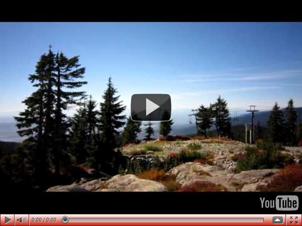
After our lunch we start to make our way back down.  However, rather than returning the way we had come up we made a circular route by walking around the back of the peak and joining the Mt Seymour Trail down the mountainside.

More lovely autumnal colours.

IMG_2853

Where are the bridge surveyors here ? !   Given it is the end of the season and will likely get crushed by snow over the winter anyway they probably won’t do anything with this until late Spring or early Summer next year.

IMG_2854

It is a testament as to quite how much snow they get up here in the winter.  The trail we are on is also a snowshoe route during the winter so trail markers need to be visible all year around – see how high they put markers on this tree – the lowest for summer hiking and then the two others remain visible depending on how much snow there is.

IMG_2856 This trail winds back down the mountain in a small forested valley.

IMG_2858 A small clearing with some creeks.

IMG_2859

And a short detour so we can reach First Lake (which we have passed before on our way to and from Dog Mountain).  Tremendous reflections in the clear still water…………

IMG_2860

…….that is until the big furry beast jumps in.

After some more good swimming we head back along the Dog Mountain trail back to the car.

It had been an absolutely perfect walk in beautiful weather and the views were astounding, much better than the hiking book had led us to believe there would be.  I definitely want to do some more walks up here in the future.

Two Canyon Loop, October 2010

This week Mojo and I revisited the Two Canyon Loop trail which we last walked in 2009 and it was during that walk our camera broke. Armed with the long since replaced new camera on a bright and sunny fall day we headed over to Lynn Canyon.

IMG_2802

We don’t often walk at Lynn Canyon largely because of the crowds but I thought an average October Tuesday might not be too bad.  However, two school busses parked, a full parking lot and a number of out-of-province license plates suggested it still wasn’t going to be quiet.

IMG_2799

We pass the very impressive cafe and visitors centre.

IMG_2801

Before approaching the bridge we can already see it’s going to be busy.

IMG_2800 Despite being fussed, commented on, patted and poked by tourists Mojo is excellent on the bridge and just pushes his way through and gets to the other side as quickly as possible.  I do too so no photos from the bridge.

We take riverside trail, Mojo amongst the fallen leaves.

IMG_2743

We reach 30’ Pool and its beautiful clear waters.

IMG_2744

Mojo takes the opportunity for a quick paddle.

IMG_2748 Then we are faced with the giant staircase to take us back up the canyon side.

IMG_2749 Views back down the staircase with the autumnal colours.

IMG_2750 At the top of the rise we turn left and reach the Varley Trail where we make a short detour to the first pipeline bridge, these views down to the canyon a long way below.

IMG_2751 We then proceed back up to the edge of the Seymour Conservation Reserve and down the Homestead trail into the Seymour River Canyon. Similar to the Lynn Canyon this is proper North rainforest with lots of moss covered trees.

IMG_2754

Giant older 2nd generation trees completely covered in moss.

IMG_2755 Here there is a substantial new growth tree that has grown completely out of the old stump of a felled old-growth tree.

IMG_2757

The Seymour Conservation Reserve is one of the few locations on the North Shore that restricts dogs because of its particularly environmentally sensitive nature.  Mojo isn’t impressed, but he does have an awful lot of places he can run around.

IMG_2758

We don’t need to go along this trail anyway and we take a right at this point onto Fishermans Trail which runs alongside the Seymour River.

This riverside trail is much more open with less dense deciduous trees.

IMG_2759 Seymour River.

IMG_2760

We eventually reach the blue bridge which we will cross.

IMG_2764

The views upstream from the middle of the blue bridge.

IMG_2763

We continue the walk along the East side of the Seymour River before reaching yet another pipeline bridge seen through the trees ahead.

IMG_2765 The river rushes through the narrow canyon below the bridge.

IMG_2766 Now we must make another steep ascent as we climb back up the canyon side back towards Lynn Canyon.  This starts with a very steep staircase followed by extensive switchbacks.

IMG_2767 Mojo takes a break for a moment.  Probably praying I won’t throw his stick all the way back down the stairs…….again.

IMG_2768 After some climbing the trail levels out and we soon cross Lillooet Road, which is the access road cut through the forest to the Seymour Conservation Reserve and the water filtration plant nearby.  It’s a strangely busy throughfare to find when you feel you’re stomping through forest in the middle of nowhere.

IMG_2769 After re-entering the forest on the Lynn Canyon side we hear and see a woodpecker a short way from the trail.

IMG_2783

This video of him tapping away, pull off pieces of the bark to get at the insects underneath.

After a good ten minutes or so of watching him snack he flies off and tries his luck on another tree.  We then see the damage he has managed to cause to this tree which is where he was when we first saw him.

IMG_2787

We carry on with our walk and soon back at our old faithful Lynn Creek.

IMG_2789

Further along the trail we come to the Twin Falls.  This is the upper of the two small drops.

IMG_2791 Nearby is the bridge we need to cross the river.

IMG_2796

There were good views to the naked eye of the falls from the bridge but the contrast between bridge sunlight and shade meant it didn’t photograph well.

IMG_2792 On the North side of the bridge are beautiful colourful pools in the river canyon.

IMG_2794 Finally as we make our way back up towards the parking lot at Lynn Canyon, a glimpse through the trees of the suspension bridge…..still busy.

IMG_2798